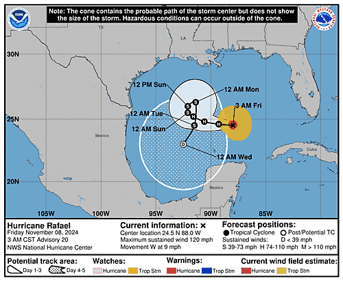
Issued at 300 AM CST Fri Nov 08 2024
000
WTNT43 KNHC 080846
TCDAT3

Hurricane Rafael Discussion Number  20
NWS National Hurricane Center Miami FL       AL182024
300 AM CST Fri Nov 08 2024

Satellite images depict Rafael continues to produce deep convection,
with cloud tops around -80 C.  However, in the last few hours, the
eye has become more cloud filled and less pronounced. Subjective
Dvorak satellite intensity estimates this cycle were T/5.5 and
T/6.0, from TAFB and SAB respectively. Objective satellite intensity
estimates from UW-CIMSS range from 100-119 kt. Using a blend of
these estimates, the initial intensity is set to 105 kt.  An Air
Force Hurricane Hunter aircraft is scheduled to investigate the
system in a few hours.

The initial motion is 275/8 kt, and a general westward to
west-northwestward motion is expected during the next 48 h or so as
Rafael continues to be steered by a building ridge to the north.
Model guidance has come into a little better agreement this cycle,
with the latest operational ECMWF and UKMET leaning towards the GFS
solution, which shows a slow anticyclonic meandering loop over the
central Gulf of Mexico. Although there remains some ensemble
divergence, the ensemble means are in better agreement as well. As
the Rafael weakens, the low-level flow then causes the system to
move southwestward in the Gulf of Mexico through the end of the
forecast period. The NHC track was shifted towards these model
trends and lies near to the simple and corrected-consensus aids.

Rafael is currently in an area of light vertical wind shear, and
warm sea surface temperatures. Some intensity fluctuations are
possible today. By tonight, westerly shear is forecast to increase
slightly, and a drier airmass will begin to impact the system. This
should cause Rafael to steadily weaken throughout the forecast
period, and the latest NHC intensity forecast follows the latest
model weakening trends. Model simulated IR satellite depicts that
the system will struggle to produce convection by the end of the
period, and the latest NHC forecast shows the system becoming a
remnant low in 120 h. Although, some models like the GFS depict that
this could occur sooner than currently forecast.


Key Messages:

1. Swells generated by Rafael are likely to cause life-threatening
surf and rip current conditions along the Gulf Coast for the next
few days.

2. Rafael is forecast to move slowly over the central Gulf of
Mexico this weekend and early next week. Interests in the southern
and southwestern Gulf of Mexico should monitor the progress of this
system.


FORECAST POSITIONS AND MAX WINDS

INIT  08/0900Z 24.5N  88.0W  105 KT 120 MPH
 12H  08/1800Z 24.6N  89.3W   95 KT 110 MPH
 24H  09/0600Z 24.8N  90.6W   80 KT  90 MPH
 36H  09/1800Z 25.2N  91.6W   65 KT  75 MPH
 48H  10/0600Z 25.5N  92.1W   55 KT  65 MPH
 60H  10/1800Z 26.0N  92.1W   45 KT  50 MPH
 72H  11/0600Z 26.3N  91.4W   40 KT  45 MPH
 96H  12/0600Z 24.5N  91.5W   35 KT  40 MPH
120H  13/0600Z 23.0N  92.5W   30 KT  35 MPH...POST-TROP/REMNT LOW

$$
Forecaster Kelly

