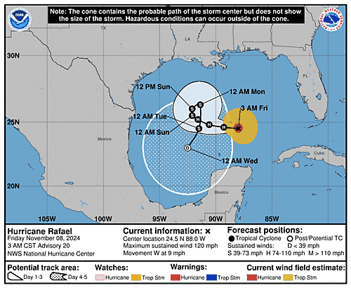
Issued at 900 PM CST Thu Nov 07 2024
000
WTNT43 KNHC 080253
TCDAT3

Hurricane Rafael Discussion Number  18
NWS National Hurricane Center Miami FL       AL182024
900 PM CST Thu Nov 07 2024

Satellite imagery this evening shows that Rafael has become better
organized, with the eye becoming more distinct and the cloud tops
in the eyewall getting colder. However, reports from an Air Force
Reserve Hurricane Hunter aircraft indicate that this has not yet
resulted in strengthening. The central pressure is near 965 mb, and
a combination of 700-mb flight level winds and dropsonde data
supports an initial intensity of 90 kt.  Interestingly, this is at
the lower end of the various subjective and objective satellite
intensity estimates.

The initial motion is now 280/8 kt, and a general westward to
west-northwestward motion is expected during the next 48 h or so as
Rafael is steered by a building ridge to its north.  After that,
the track guidance is still quite divergent. The Canadian, NAVGEM,
and COAMPS-TC models call for the cyclone to turn northward or
northeastward toward the northern Gulf coast as it gets affected by
the large deep-layer trough over the southwestern United States.
The GFS, which previously supported this scenario, is now calling
for a slow anticyclonic loop over the central Gulf of Mexico, and
this is also the forecast of the GFS and UKMET ensemble means. The
ECMWF, deterministic UKMET, and the GFS-based regional hurricane
models still show a turn toward the southwest and south as a narrow
ridge builds between the hurricane and the aforementioned trough.
To add to the uncertainty, the GFS and ECWMF ensembles still have
numerous tracks supporting both the northward and southward turns.
Based on the continued guidance spread and continuity from the
previous forecast, the new track forecast continues to lean toward
the southward scenario, although the new track is a little slower
than the previous track to match the overall slower set of guidance.

Rafael is currently in an area of light vertical wind shear, and
the hurricane is crossing a warm eddy in the Loop Current. This
combination should at least maintain the current intensity for the
next 12-24 h, and slight strengthening cannot be ruled out.  After
that, westerly shear is forecast to increase, and while the shear
is not likely to be strong it should help advect very dry air into
the circulation. This should cause Rafael to steadily weaken, and
the intensity forecast has been adjusted to show an increased
weakening rate between 24-60 h to better fit the trend of the
guidance.  The intensity forecast generally follows the faster
weakening rate of the global and GFS-based regional hurricane
models, as the statistical-dynamical models have a slower rate of
weakening.  It should be noted that if Rafael turns northward, it
would move over cooler sea surface temperatures and encounter
stronger shear, which would likely cause a faster weakening than
currently forecast.


Key Messages:

1. Swells generated by Rafael are likely to cause life-threatening
surf and rip current conditions along the Gulf Coast for the next
few days.

2. Rafael is forecast to move slowly over the central Gulf of
Mexico this weekend and early next week. Interests in the southern
and southwestern Gulf of Mexico should monitor the progress of this
system.


FORECAST POSITIONS AND MAX WINDS

INIT  08/0300Z 24.6N  87.1W   90 KT 105 MPH
 12H  08/1200Z 24.7N  88.4W   90 KT 105 MPH
 24H  09/0000Z 24.8N  89.9W   85 KT 100 MPH
 36H  09/1200Z 25.1N  91.1W   70 KT  80 MPH
 48H  10/0000Z 25.2N  91.9W   60 KT  70 MPH
 60H  10/1200Z 25.3N  92.4W   50 KT  60 MPH
 72H  11/0000Z 24.9N  92.7W   45 KT  50 MPH
 96H  12/0000Z 23.7N  93.1W   35 KT  40 MPH
120H  13/0000Z 22.0N  93.9W   30 KT  35 MPH

$$
Forecaster Beven

