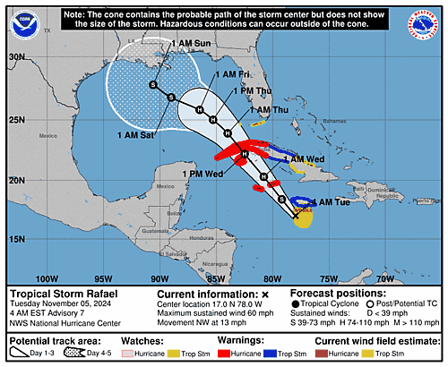
Issued at 400 PM EST Sun Nov 03 2024
000
WTNT43 KNHC 032054
TCDAT3

Potential Tropical Cyclone Eighteen Discussion Number   1
NWS National Hurricane Center Miami FL       AL182024
400 PM EST Sun Nov 03 2024

The Air Force Hurricane Hunters have been investigating the
disturbance over the south-central Caribbean Sea and their data
indicates that the system has developed a closed center. However,
deep convection is not quite organized enough to designate the
system a tropical depression at this time. Given the potential for
development and impacts to Jamaica and the Cayman Islands during the
next day or two, advisories are being issued on Potential Tropical
Cyclone Eighteen.

The initial motion is northeastward at 6 kt, but this is uncertain
given that the system has only recently closed off. A turn to the
north and then northwest is expected over the next couple of days as
a mid-level ridge builds across the southwestern Atlantic and the
eastern Caribbean. This motion should take the disturbance near
Jamaica by late Monday and near or over the Cayman Islands and Cuba
on Tuesday and Wednesday. The models are in relatively good
agreement during that time period, and the official track forecast
lies near the various consensus models. Once the system reaches the
Gulf of Mexico by the middle of the week, the model solutions
diverge due to differences in the predicted steering patterns and
vertical depth of the system by that time. Therefore, the NHC track
forecast during that time period is of notably lower confidence.

The environmental conditions appear conducive for strengthening
during the next few days, and it seems likely that the system will
become a tropical storm before it reaches Jamaica and a hurricane
before it reaches Cuba. However, later in the week, southwesterly
vertical wind shear and intrusions of dry air should end the
strengthening process and likely induce some weakening once the
system reaches the Gulf of Mexico. The hurricane regional models are
very aggressive, however, their intensity predictions appear
overdone, at least in the short term. The NHC intensity forecast is
closer to the statistical-dynamical models DSHP and LGEM and near
the IVCN consensus aid.


Key Messages:

1. The disturbance is expected to become a tropical storm Monday and
pass near Jamaica on Monday night and Tuesday where a Tropical Storm
Warning is now in effect. The system is forecast to become a
hurricane by Tuesday night and there is a risk of dangerous impacts
from hurricane-force winds and storm surge in the Cayman Islands and
portions of Cuba.

2. Interests in the Florida Keys should closely monitor this system
as tropical storm watches could be required for portions of the
Florida Keys tonight or early Monday.

3. The system is forecast to approach the northern Gulf Coast as a
tropical storm later this week, but given uncertainties in the
long-range forecast, it is too soon to determine what, if any,
impacts could occur. Residents in this area should regularly
monitor updates to the forecast.

4. The system will bring areas of heavy rain across portions of the
western Caribbean, including Jamaica and the southern and western
portions of Cuba through mid-week. Flooding could occur over
portions of Jamaica and Cuba, with mudslides possible. Heavy
rainfall could then spread northward into Florida and adjacent
areas of the Southeast United States during the middle to late
portions of the week.


FORECAST POSITIONS AND MAX WINDS

INIT  03/2100Z 13.0N  77.1W   30 KT  35 MPH...POTENTIAL TROP CYCLONE
 12H  04/0600Z 14.3N  77.1W   35 KT  40 MPH...TROPICAL CYCLONE
 24H  04/1800Z 16.0N  77.7W   40 KT  45 MPH
 36H  05/0600Z 17.7N  78.6W   50 KT  60 MPH
 48H  05/1800Z 19.6N  80.4W   60 KT  70 MPH
 60H  06/0600Z 21.5N  82.6W   70 KT  80 MPH
 72H  06/1800Z 23.3N  84.5W   65 KT  75 MPH
 96H  07/1800Z 25.4N  86.6W   60 KT  70 MPH
120H  08/1800Z 26.9N  88.6W   50 KT  60 MPH

$$
Forecaster Cangialosi

