Issued at 400 PM CDT Tue Oct 08 2024
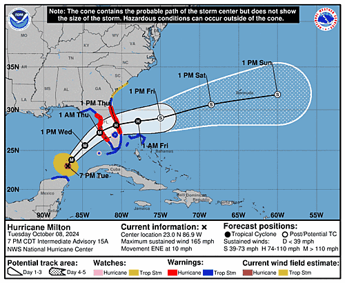
648
WTNT44 KNHC 082054
TCDAT4

Hurricane Milton Discussion Number  15
NWS National Hurricane Center Miami FL       AL142024
400 PM CDT Tue Oct 08 2024

The Air Force Reserve Hurricane Hunters found that Milton's central
pressure had fallen to 923 mb in the last pass they made through
the eye a few hours ago.  The satellite presentation has improved
since that time, with a thick ring of cold cloud tops surrounding a
10-mile-wide eye.  This pattern yielded a T7.0/140 kt from TAFB,
with several of the objective satellite estimates between 140 and
145 kt.  Milton has again become a category 5 hurricane, with
maximum winds estimated to be 145 kt.  Another Air Force mission is
entering Milton as we speak.

Milton wobbled a bit to the southeast today, but the longer-term
12-hour motion is east-northeastward (075/8 kt).  Milton is forecast
to turn northeastward and begin accelerating later today as it moves
between a trough digging into the Gulf of Mexico and a ridge near
the Greater Antilles.  Because of the wobble, the track guidance
has been initialized a bit to the south of where many of the raw
model fields think the hurricane was centered at 1800 UTC, and this
has caused the entire guidance envelope to shift a bit south on
this cycle.  It is still critical to remember that even at 36 hours
(around the time of potential landfall), NHC's track forecasts
can be off by an average of 60 n mi, which means we still can't
pinpoint an exact landfall location, especially if additional
wobbles occur in the short term.  After landfall, Milton is
forecast to cross Florida and emerge over the Atlantic waters on
Thursday.

Milton is expected to maintain major hurricane strength while it
moves across the Gulf of Mexico and approaches the west coast of
Florida.  Stronger vertical shear is expected to increase in about
24 hours, but even if this causes some weakening, it will likely not
be enough to keep Milton from being an extremely dangerous hurricane
when it reaches shore.  Additionally, the first stages of
extratropical transition may be just underway as Milton is reaching
the coast, which could impart some baroclinic energy and slow the
rate of weakening.  The NHC intensity forecast is close to the top
end of the model envelope, which includes the GFS and ECMWF models,
since these models should have a better handle on a potential
positive trough interaction.

Milton's wind field is expected to expand as it approaches Florida.
In fact, the official forecast shows the hurricane and
tropical-storm-force winds roughly doubling in size by the time it
makes landfall.  In addition, the stronger-than-normal winds could
occur on the northwest/back side of the storm since Milton will be
interacting with a frontal boundary and beginning extratropical
transition.  Damaging winds, life-threatening storm surge, and heavy
rainfall will extend well outside the forecast cone.  This is a
very serious situation and residents in Florida should closely
follow orders from their local emergency management officials.
Evacuations and other preparations should be completed today.
Milton has the potential to be one of the most destructive
hurricanes on record for west-central Florida.


Key Messages:

1. A large area of destructive storm surge,  with highest
inundations of 10 ft or greater, is expected along a portion of the
west-central coast of the Florida Peninsula.  If you are in the
Storm Surge Warning area, this is an extremely life-threatening
situation, and you should evacuate today if ordered by local
officials.  There will likely not be enough time to wait to leave on
Wednesday.

2. Devastating hurricane-force winds are expected along portions of
the west coast of Florida, where a Hurricane Warning is in effect.
Milton is forecast to remain a hurricane as it crosses the Florida
Peninsula and life-threatening hurricane-force winds, especially in
gusts, are expected to spread inland across the peninsula.
Preparations to protect life and property, including being ready for
long-duration power outages, should be complete by tonight.

3. Heavy rainfall across the Florida Peninsula through Thursday
brings the risk of catastrophic and life-threatening flash and urban
flooding along with moderate to major river flooding, especially in
areas where coastal and inland flooding combine to increase the
overall flood threat.

4. Tropical storm conditions and a dangerous storm surge with
destructive waves will continue across portions of the northern
coast of the Yucatan Peninsula this evening.


FORECAST POSITIONS AND MAX WINDS

INIT  08/2100Z 22.7N  87.5W  145 KT 165 MPH
 12H  09/0600Z 23.8N  86.4W  145 KT 165 MPH
 24H  09/1800Z 25.6N  84.7W  130 KT 150 MPH
 36H  10/0600Z 27.2N  82.8W  110 KT 125 MPH
 48H  10/1800Z 28.1N  80.7W   75 KT  85 MPH...INLAND
 60H  11/0600Z 28.6N  77.9W   65 KT  75 MPH...OVER WATER
 72H  11/1800Z 29.0N  75.0W   55 KT  65 MPH...POST-TROP/EXTRATROP
 96H  12/1800Z 30.6N  68.5W   45 KT  50 MPH...POST-TROP/EXTRATROP
120H  13/1800Z 31.8N  60.0W   40 KT  45 MPH...POST-TROP/EXTRATROP

$$
Forecaster Berg