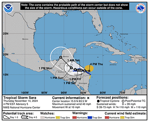
Issued at 1000 AM EST Thu Nov 14 2024
000
WTNT44 KNHC 141450
TCDAT4

Tropical Depression Nineteen Discussion Number   4
NWS National Hurricane Center Miami FL       AL192024
1000 AM EST Thu Nov 14 2024

Latest satellite imagery depicts that the system continues to become
better organized this morning, with improved curved banding
features, and deep convection consolidating near the low-level
center. The latest subjective intensity estimates were T/2.5 from
both TAFB and SAB. The initial intensity is set to 30 kt, and an Air
Force Hurricane Hunter aircraft is about to enter the system which
will provide more information on current intensity and structure.

The cyclone is moving westward with an estimated motion of 265/12
kt. A strong mid-level ridge located to the north of the system will
continue steer the system westward towards Central America. The
ridge is expected to break down, and the cyclone will meander in
weak steering currents, Friday through the weekend. This expected
slow motion will cause the system to produce heavy rains over the
same region, likely causing life-threatening flooding over portions
of Central America. By early next week, the mid-level ridge should
slide eastward over Florida, which should cause the system to move
northwestward across Belize and the Yucatan Peninsula. The NHC track
forecast is in good agreement with the various consensus models, and
is nudged slightly left towards the latest model trends.

Environmental and oceanic conditions are conducive for some
strengthening during the next day or so while the cyclone remains
over water. There remains uncertainty in how much land interaction
there will be with Honduras during the next several days, but the
model trends have been southward showing more interaction. If the
system remains along the coast or just offshore, it will likely
maintain intensity or slightly strengthen. However, if the
depression moves a little south of the forecast track, the system
could be weaker than shown below. Given the slight leftward track
adjustment with potentially more land interaction, the latest NHC
intensity forecast is lower than the previous and is near the middle
of the guidance envelope. However, it must be stressed that there is
still a lot of uncertainty in the intensity forecast.

KEY MESSAGES:

1. Through early next week, heavy rainfall will cause significant,
life-threatening flash flooding and mudslides across portions of
Central America, particularly Honduras, Belize, El Salvador, eastern
Guatemala, and western Nicaragua.

2. Tropical storm conditions are expected along portions of the
northern coast of Honduras, and the adjacent Bay Islands where
tropical storm warnings are in effect.

3. The system is forecast to approach Belize and the Yucatan
Peninsula of Mexico by early next week where there is a risk of
strong winds. Residents in these areas should monitor the latest
forecast updates.

4. It is too soon to determine what impacts, if any, the system
could bring to portions of the eastern Gulf of Mexico, including
Florida, during the middle portion of next week. Residents in these
areas should regularly monitor updates to the forecast.


FORECAST POSITIONS AND MAX WINDS

INIT  14/1500Z 15.7N  82.6W   30 KT  35 MPH
 12H  15/0000Z 15.7N  83.7W   35 KT  40 MPH
 24H  15/1200Z 15.9N  84.9W   40 KT  45 MPH...NEAR THE COAST
 36H  16/0000Z 15.9N  85.4W   40 KT  45 MPH...NEAR THE COAST
 48H  16/1200Z 15.9N  85.8W   40 KT  45 MPH...NEAR THE COAST
 60H  17/0000Z 16.0N  86.2W   45 KT  50 MPH...NEAR THE COAST
 72H  17/1200Z 16.2N  87.0W   45 KT  50 MPH...OVER WATER
 96H  18/1200Z 18.0N  89.6W   30 KT  35 MPH...INLAND
120H  19/1200Z 21.7N  91.6W   30 KT  35 MPH...OVER WATER

$$
Forecaster Kelly

