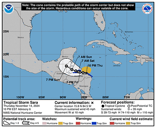
Issued at 400 PM EST Wed Nov 13 2024
000
WTNT44 KNHC 132053
TCDAT4

Potential Tropical Cyclone Nineteen Discussion Number   1
NWS National Hurricane Center Miami FL       AL192024
400 PM EST Wed Nov 13 2024

Showers and thunderstorms associated with the broad area of low
pressure over the central Caribbean Sea that the National Hurricane
Center has been monitoring have increased and are showing signs
of organization. While some mid-level rotation is evident in
visible satellite images near a recent burst of convection, the
low-level circulation remains broad and elongated. However, the
system is expected to become a tropical storm within the next day or
so and it is likely to bring tropical storm or hurricane conditions
to land areas within the next 36 to 48 hours. Therefore, the
National Hurricane Center is initiating Potential Tropical Cyclone
advisories for this disturbance.

The initial motion is more uncertain than normal since the system is
still in the formative stage, but the best estimate is westward at
about 5 kt. A continued westward motion is anticipated during the
next few days with a slower forward speed as the system moves into
the western Caribbean Sea. As steering currents weaken, the system
is forecast to meander just offshore, or along the coast of Central
America for a couple of days late this week and over the weekend.
Later in the period, the ridge to the north, begins to erode and
slide eastward as a mid-level trough digs into the western Gulf of
Mexico, which will induce a northwestward motion towards the end of
the forecast period. Model guidance is in fairly good agreement with
the overall track evolution, however they differ on potential land
interaction in Central America, and if the system moves onshore and
how long it remains inland. The NHC forecast lies near the consensus
models, near HCCA and TVCA consensus aids. Since the disturbance
currently lacks a well-defined center, users are reminded that the
average forecast track uncertainty is larger in these situations,
and future track adjustments may be required.

The models suggest a more well-defined center should develop during
the next day or so. Once the system becomes better organized and
develops an inner core, the environmental conditions appear
favorable for strengthening. Thus, the NHC forecast shows
strengthening while the system moves into the western Caribbean sea.
However, there remains higher than normal uncertainty in the
intensity forecast due to potential land interactions. If the system
remains over water, it could be stronger than indicated below, but
if it moves over Central America weakening would occur.  The NHC
forecast lies near the consensus aids given this uncertainty.

Based on the NHC forecast, Tropical Storm and Hurricane
Watches have been issued for portions Nicaragua and Honduras.

KEY MESSAGES:

1. Through early next week, heavy rainfall will cause significant,
life-threatening flash flooding and mudslides across portions of
Central America, particularly Honduras, Belize, El Salvador,
eastern Guatemala, and western Nicaragua.

2. The disturbance is forecast to be near hurricane strength when
it moves near the eastern coast of Honduras and northeastern
Nicaragua on Friday and Saturday.  Hurricane and tropical storm
conditions are possible over portions of that area.

3. The system is forecast to approach Belize and the Yucatan
Peninsula of Mexico at or near hurricane strength by early next week
where there is a risk of dangerous storm surge and damaging winds.
Residents in these areas should monitor the latest forecast updates
and ensure that they have their hurricane plan in place.

4. It is too soon to determine what impacts the system could bring
to portions of the eastern Gulf of Mexico, including Florida, the
Florida Keys, and Cuba during the middle portion of next week.
Residents in these areas should regularly monitor updates to the
forecast.


FORECAST POSITIONS AND MAX WINDS

INIT  13/2100Z 16.2N  79.0W   25 KT  30 MPH...POTENTIAL TROP CYCLONE
 12H  14/0600Z 16.2N  80.9W   30 KT  35 MPH...TROPICAL CYCLONE
 24H  14/1800Z 16.3N  83.0W   35 KT  40 MPH
 36H  15/0600Z 16.4N  84.3W   45 KT  50 MPH
 48H  15/1800Z 16.4N  84.8W   60 KT  70 MPH
 60H  16/0600Z 16.3N  84.8W   60 KT  70 MPH
 72H  16/1800Z 16.1N  84.7W   60 KT  70 MPH
 96H  17/1800Z 16.3N  85.4W   60 KT  70 MPH
120H  18/1800Z 18.3N  88.5W   55 KT  65 MPH...INLAND

$$
Forecaster Kelly

