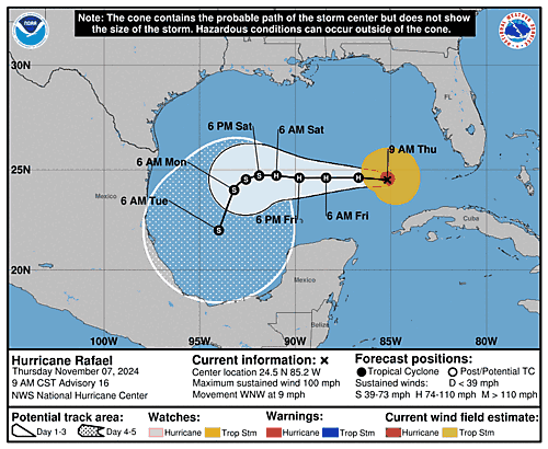
Issued at 900 AM CST Thu Nov 07 2024
000
WTNT43 KNHC 071453
TCDAT3

Hurricane Rafael Discussion Number  16
NWS National Hurricane Center Miami FL       AL182024
900 AM CST Thu Nov 07 2024

The Air Force and NOAA Hurricane Hunters have been investigating
Rafael this morning. Tail Doppler Radar data and reports from the
flight crews, in addition to earlier passive microwave imagery,
indicate the eyewall has opened up to the south and southwest of the
center. This is likely due to the negative influences of some drier
mid-level air and westerly shear. The Air Force Hurricane Hunters
have reported peak 700-mb flight-level winds of 92 kt, and dropsonde
data indicate the central pressure has risen slightly to around 971
mb. Given the latest flight-level wind data and some erosion of the
eyewall convection, the initial intensity is lowered to 85 kt.

The hurricane is expected to move into an even drier airmass over
the next few days, with at least weak to moderate westerly shear
over the system. So despite 27-28 deg C SSTs over the southern Gulf
of Mexico, some additional weakening is forecast through this
weekend into early next week. Rafael should remain a hurricane for
the next couple of days, but some downward adjustments were made to
the NHC intensity forecast to bring it closer to the latest
multi-model consensus aids. Even still, the NHC forecast lies on the
higher side of the guidance envelope.

Recent aircraft fixes indicate Rafael is beginning a leftward turn,
and the initial motion estimate is west-northwestward at 295/8 kt.
The hurricane should move westward over the next couple of days as a
mid-level ridge builds to its north. Then, there is still some
spread in the track guidance with a bifurcation in model solutions.
Most of the models (including the ECMWF, UKMET, and regional
hurricane models) show Rafael turning southwestward in response to a
narrow ridge building to its northwest. But, the GFS and Canadian
models still suggest a northward turn ahead of a slightly deeper
upper trough over the central United States. The NHC prediction
continues to favor the southern solutions and is similar to the
previous forecast, in agreement with the majority of track models
and consensus aids. There remains above average uncertainty in the
future track of Rafael, and additional adjustments to subsequent
official track forecasts are likely. If the northern model solutions
were to verify, Rafael would likely encounter even more hostile
environmental conditions and weaken faster than shown in the
official NHC forecast.


Key Messages:

1. Hurricane Rafael will continue to bring periods of heavy rain to
western Cuba today. Flash flooding and mudslides are possible along
the higher terrain.

2. Rafael is forecast to move slowly over the south-central Gulf of
Mexico this weekend and early next week. Interests in the southern
and southwestern Gulf of Mexico should monitor the progress of this
system.


FORECAST POSITIONS AND MAX WINDS

INIT  07/1500Z 24.5N  85.2W   85 KT 100 MPH
 12H  08/0000Z 24.6N  86.7W   85 KT 100 MPH
 24H  08/1200Z 24.6N  88.4W   80 KT  90 MPH
 36H  09/0000Z 24.6N  89.8W   75 KT  85 MPH
 48H  09/1200Z 24.7N  91.0W   65 KT  75 MPH
 60H  10/0000Z 24.7N  91.9W   60 KT  70 MPH
 72H  10/1200Z 24.5N  92.6W   55 KT  65 MPH
 96H  11/1200Z 24.0N  93.2W   45 KT  50 MPH
120H  12/1200Z 22.0N  94.0W   35 KT  40 MPH

$$
Forecaster Reinhart

